As one of New Zealand Cycle Trails 23 Great Rides, you will find Hawke's Bay Trails a Grade 1&2 Easy ride. What this means is trails are flat and mostly off-road, so well suited to pathway, cycle touring, mountain or electric bikes. You can enjoy relaxed, short rides of an hour or two with the family, or spend a few days exploring with friends, seeing all the Trails have to offer.
The Trails are made up of three different experiences: The Water Ride (imagine riding beside Ocean, Estuary and Rivers), The Wineries Ride (think wine country with vineyards and cellar doors) and The Landscapes Ride, (envision expansive views including Cape Kidnappers, Te Mata Peak) and the only place to expect a few hills is on the Tukituki Loop, with the views making up for it.
Our Trails have mostly a lime-sand surface for quiet, safe riding. Some Trails have on-road connections with Napier/Hastings city iWay Routes and you can even take your bike on a bus between Hastings – Napier.
Finding your way is easy and there are lots of ways:
Before you go check the latest weather from MetService or the local Marine Parade webcam
And after your ride, we'd love your feedback. Fill in the New Zealand Cycle Trail Survey and you could win a monthly prize.
Recommended Rides:

Distance: 35km
Trail Status: Open
Surface: Concrete and lime sand sections
Traffic: Light to Heavy
Grade: 1
This section of Hawke’s Bay Trails starts from Ahuriri in Napier, near East Pier Hotel. It runs along the coast towards Bayview, to wetlands which were part of the old inner harbour. It returns past the airport with an optional loop extension to the base of the Poraiti foothills. An alternative start with plenty of parking and a map board, is across the road from the Westshore Beach Inn, on Meeanee Quay. Activities to stop and explore on the way include: the Ahuriri fishing precinct, cafés, restaurants, playgrounds, coffee houses and bird hides. This section has a rich history – rare migrating birds, historic maritime beacons, Māori history and the lasting effects of 1931’s brutal earthquake.
The popular trail from Ahuriri to Bay View is concrete, about 7km in length and accessible for all recreational uses including hand bikes, wheelchairs, recumbents and trikes. It is an easy, flat ride to the end of the concrete. After the concrete, the trail is more suitable for standard bikes due to lime sand sections, gates cross a working farm - sheep and cattle may be present. This section from Onehunga Rd to the airport will be wet after rain, due to the high-water table - avoid for several days after heavy rainfall.
At Bay View, an intersection means you can stay on Ferguson Road to the end and ride through the campground to Snapper Café OR cross at the railway crossing, and over the main road to head down Onehunga Road.
This is where the trail leads to wetlands, past the DOC carpark and Whakamaharatanga Walkway. This hill in front of you was an island prior to the 1931 earthquake. Rorookuri Island was in the original Te Whanganui ā Orotū lagoon and its archaeological features are of much interest. This island had two old pā sites and rich in Māori history. It is culturally and archaeologically very significant, please respect this. Always follow the limesand trails around the base ONLY, where you can imagine it once being below sea level. The limesand trail is for walking and cycling only, it buffers a conservation land teeming with bird life and a working farm, it's a privilege we need to respect. Stay on the designated limesand trail only, do not ride or walk around the farm.
If you want to see the panoramic view of Hawke's Bay from the top of Rorookuri, please lock your bikes at the bottom and walk the designated DOC track up ONLY - DO NOT ride up the hill.
Once past the airport, there is an underpass crossing at the expressway/railway bridges where the trail continues to natural wetlands of the upper harbour. Stop off at the bird hides - see how many native or different species you spot out of: Royal Spoonbill, White and Grey Heron, Godwits, Ducks, Swans, Oystercatchers, Plovers, Shags, Stilts, Pukekos, Terns and Kingfisher. The trail then exits across and beside Prebensen Drive, returning to the bridges, creating a loop and connecting back to Ahuriri.
The big loop is about 35km OR break it into easy sections for shorter options. If you don't have a bike then just hire one from any of the local hire places located in Napier: Bike About Tours Napier, Beach Bikes, Napier City Bike Hire or Takaro Trails.
Go right to the end of Ferguson Road, through a gap in the fence and through the campground to enjoy a café stop at Snapper Cafe.
Book in for a beach side sauna session with The Sauna Project Napier located at Napier Port Beach or West Shore Beach. Experience the contrast between the heat of the sauna and the cold of the ocean. Bookings are limited, so make sure you book in advance.
Bay View is a great spot to base yourself with both Napier Beach Kiwi Holiday Park & Motels. Or for something more central in Napier try Kennedy Park, with its great range of options
Thinking an extended lunch? Go a little bit further to Crab Farm Winery. Or do the whole lot and check out numerous dining venues on the Ahuriri or Napier waterfront for a later booking. A recommended stop if you enjoy wines is the Urban Winery, check out the famous 'Egg' and taste Tony Bish Wines, located in the historic National Tobacco Company Art Deco building, Ahuriri.
The underpasses at Ahuriri Lagoon can sometimes get trail surface flooding, at high tides. If wet, dismount and walk your bike through. On the Airport/Westshore side the detour is to double back and use Watchman Rd as an alternative.
 Distance: 15km one way or 30km return
Trail Status: Open
Surface: Concrete and lime sand sections
Traffic: Light to Heavy
Grade: 1
This section of Hawke’s Bay Trails starts at Ahuriri, near East Pier Hotel. It passes Napier Port, parks, gardens and numerous fun attractions for the kids. There are many places you can park a vehicle beside the trail and get started – just check time limits. This popular urban section of trail is shared with many users and accessible for hand bike, wheelchairs, recumbents and trikes. If you don't have a bike then just hire one from any of the local hire places located in Napier: Bike About Tours Napier, Beach Bikes, Napier City Bike Hire or Takaro Trails.
Activities to stop and indulge on the way include: the iconic Napier ‘cloud’ viewing platform, mini-golf, the sunken garden, ice-cream shops, skate park, playgrounds, historic building, coffee houses, junior bike park, pump park and the National Aquarium. The Napier i-SITE Visitor Centre is located near the Sound Shell, just off the trail and they have a bike pump/repair station located outside the toilets. If you are looking for an indulgent weekend we recommend 415 Marine Parade, located right on the trails.
As you leave the city limits the trail stretches out beside the ocean. It is an easy, mostly flat ride to Waitangi Regional Park, worth a short lime sand detour to see the stunning Star Compass, Ātea A Rangi. Stop here for a photo, learn about early European settlers and how Māori ancestors used the sun, moon and stars to navigate throughout the Pacific Ocean on sailing canoes known as waka.
Leaving the bridges and concrete section of trail, turn left, go through the gate onto a lime sand section and to join the Clive River to Clive, where there are some great places to stop for refreshments.
Clive township is the end of this section. A popular area offering a range of accommodation, with parking for self-contained campervans right through to luxury cottages.
This busy part of the trail is very popular with locals and visitors, with lots of people enjoying this area. Slow down, be prepared to stop, look out for the unpredictable, and just enjoy the vibe!
 Distance: 30km or 60k
Trail Status: Open
Surface: Lime sand and short on-road sections
Traffic: Light
Grade: 1
As the 12th Great Wine Capital of the World, you cannot say you’ve seen Hawke’s Bay without a visit to at least a few of our award winning wineries. The Wineries Ride is simply the best way to experience our vineyards and renowned terroir. Either ride the long leg from Clive (60km) via beautiful Oak Avenue, a shorter stint from Roy’s Hill Reserve (30km), or pick your own selection of cellar doors. For those you more inclined to an ale, check out Roosters Craft Brewery just off the trail.
When starting from Roy’s Hill Reserve, park at the upper carpark to go past a trails map board. Carefully cross the main road and you’re on limesand trail. Either turn left and head to Unison Vineyard or head towards the hills, to the magnificent settling of Trinity Hill Winery. Further down the road, after crossing Ngatarawa Road you’ll find Ash Ridge Wines with delightful platters.
Head back and down Ngatarawa Road to call into Oak Estate for a tasting and platter. They are just past the Oak tree and offer a great place to stop for a wine tasting and to enjoy their picnic provisions. Carry on along Ngatarawa Road to Radburnd Cellars, Kate and her team are now located at the historic Ngatarawa Winery, you will find handcrafted boutique wines, made with meticulous attention to detail. Make sure to give them a call to arrange your tasting by appointment. Continuing along the path towards the Bridge Pa Aerodrome, you can follow the trail left to Fairways Café and Bar, an upstairs retreat in surrounds of Hastings Golf Course OR turn right and follow trail past Bridge Pa village, cross again at the school and follow trail to the end before returning. Beyond Bridge Pa village you will find Abbey Cellars, with an option for beer, Alpha Domas before finishing at Sileni Estates Winery. From here go back the same way, to where you parked the car. For a longer version starting at Clive, you will be rewarded with open river sections on the way, a winery loop returning via the short on-road section via Stock Rd and Wilson Road, then through historic ‘Oak Avenue’ – majestic any time of year.
Note: Cellar doors hours will vary with the season, often closing beginning of the week and some only open in summer. We recommend checking websites for opening hours or ring them in advance to book. Both Unison and Oak Estate offer accommodation on site.
There are two cycle hire/tour providers located out on the Wineries Ride, check out On Yer Bike, also the home of Ash Ridge Wines and Ali's Cycle de Vine near Sileni Estates.

Distance: 15km
Trail Status: Open
Surface: Lime sand and short on-road sections
Traffic: Light to Moderate
Grade: 1-2
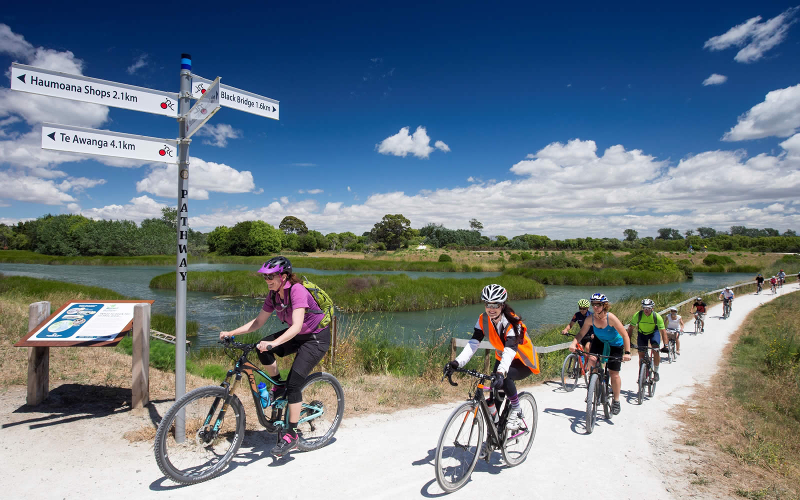
This section of the Landscapes Ride teems with creativity and activities to do. Affectionately known as Cape Coast, stop and explore on the way or nearby including cycle hire, wineries, restaurants, dairies, cute cafes, gannet safari, art studios, museums, Haumoana farmyard zoo and the legendary Cape Kidnappers golf course. Of interest is the new, developing art installations from Cape Coast Arts & Heritage Trust - find out about the history and heritage through enthralling art installations.
Start from Clive, where there is plenty of parking, toilets, coffee and supplies. If looking for accommodation check out the bike friendly Clive Colonial Cottages. Follow the trail beside the Waitangi Regional Park wetlands and along the coast before passing under Black Bridge at Tukituki River and over the clip-on crossing. Again, cross under the bridge at the end, much safer than crossing the Mill Road. This makes it easy to visit Kiosk, to learn more about the local Cape Coast Art & Heritage, before following the trail on the stopbank.
As you reach Haumoana, remember to check out the breeding ground for whitebait and if you need a toilet, you'll find one in the domain at the river mouth. You then leave the limesand section and follow a short section of road, here you will find your first coffee stop at Haumoana Coffee. Look out for signposts and follow the green bikes on the short road section to connect back to the off-road coastal trail. Here you ride beside Pohutukawa trees and pass (or stop) Brown Dog Espresso, a great coffee stop. From here follow the trail to Te Awanga and through the quaint back streets of this popular surf spot before getting back on the limesand section for the final stretch to Clifton - the gateway to Cape Kidnappers.
For an adventure check out Gannet Bikes - try taking a fat bike out to along the beach to Cape Kidnappers and the gannet colony. If you feel like a cruise around the area, hire classic beach-cruiser bikes from Coastal Wine Cycles in Haumoana. We also recommend the following Official Partners. A must check out Clearview Estate Winery, Restaurant and Cellar Door is perfect for a well deserved lunch under the vines. Or go right to the end of the trail to Clifton and enjoy a stop the new cafe - Hygge at Clifton Bay.
If you plan to stop and have lunch at any of the superb winery restaurants, we absolutely recommend booking in advance.
 Distance: 18.5k one-way or 37km return
Trail Status: Open
Surface: Short on-road sections and lime sand
Traffic: Light to Medium
Grade: 1
This popular ride can be done in either direction but we’ve started in quaint Havelock North village, with plenty of shops to explore and places to stay or hire bikes: Porters Boutique Hotel, Cycle Nation, Good Fun Bike Rides and Revolution Bikes. Enjoy beautiful views of the Heretaunga Plains, Te Mata Peak and the distant ranges.
From Havelock North village go along Te Mata Road, past the domain and turn right into Te Mata Road. Follow the cycle lanes slightly uphill and then down to the intersection of Te Mata and Te Mata Managateretere Roads. Succumb to the temptation of stopping at two famous wineries: Black Barn – the Bistro is highly recommended – and historic Te Mata Estate are both worth a stop. At the end of this road, you are beside the home of Origin Earth – cheese lovers should duck in for a tasting.
Cross the main road intersection and drop down River Road, on the trail beside the road. Enjoy the brief scenic section of woodlands before arriving at the top of the stopbank. Here the trails sit elevated beside the Tukituki River on one side, and orchards, farmlands and vineyards on the other. Plan to visit Askerne Estate Winery , follow their dedicated pathway off the stopbank, it's a great destination to enjoy making a picnic from their amazing selection and taste a local wine. For a truly unique accommodation, literally off the track, just down from Askerne, is the Villas & Vines glamping experience.
The trail stretches from River Road to the river crossing at Black Bridge, please use the underpass here, to go under and up past the carpark to access the gated section to Clive. You travel beside Waitangi Regional Park wetlands, teeming with birdlife, and follow the coast before turning down beside the Clive River to the reserve and shops at Clive. From Clive you can return or head off in the direction of your choice.
Clive is a vibrant coastal town with many great café/coffee/refreshment options, just off the trail between Napier and Hastings. If you want to use Clive as your base, check out Clive Colonial Cottages for bike friendly accommodation options.
You are best to use the underpasses always - a slight detour but much safer than crossing a busy road. As you reach Black Bridge, go under the bridge and back up, go past the carpark and head to the top of the stopbank through the trees to Clive. Or cross on the clip on and then do the same at the other end to head to Haumoana, Te Awanga or Clifton.
As you approach the coast, you enter Waitangi Regional Park, which goes all the way to Clive. This area is a sanctuary for breeding birds and great for bird watching.
Distance: 58km approx. return from Havelock North.
Trail Status: OPEN - (newly resurfaced, please use caution on soft or uneven areas of the trail)
Surface: Lime sand off-road, road crossings and on-road - hilly sections
Traffic: Light to Moderate
Grade: 3
This stunning 'loop' takes you from River Road (Havelock North) beside the majestic Te Mata Peak to Red Bridge, then a short road section downstream to Moore Rd and onto limesand trails to Black Bridge, before crossing and heading upstream to River Rd, a 30km loop trip. It is one of the most beautiful rides you’ll find anywhere. Though you’ve got to pay for the views, expect to be climbing a couple of hills to enjoy the stunning views of Te Mata, Craggy Range, and the beautiful Tuki Tuki Valley.
This loop can be ridden from River Rd or Black Bridge carparks. It is also easily ridable from Havelock North or Clive, with a few more kms. See map above for details.
Red Bridge Coffee is the perfect middle point to refuel, with caffeine and food options available. There are a few climbs (to work off those treats from Red Bridge Coffee), but it will feel like you have been transported to Tuscany with all the grapes, olives, stone walls and cypress trees. Take a moment at the top to enjoy the views back to Te Mata peak and across the Heretaunga plains. After the last hairpin corner, and about halfway down the descent watch for the turn off to Moore Road. Turn left onto Moore Road and at the bottom turn right to enter back onto the limesand stopbanks and Black Bridge. If you need a toilet about now, head under Black Bridge for a short detour (1.5km) to the river mouth and Haumoana Domain Toilets.
Once at Black Bridge cross over the river via the bridge clip-on, head left and ride back up the other side of the river to River Road, where you parked your car. Approximately at 58km return ride.
For the wine lovers, there are several amazing Hawke's Bay Great Wine experiences on this route: Black Barn Vineyards, Te Mata Estate Winery, Craggy Range and Askerne Estate Winery.
You will be spoilt for choice for accommodation near or right off the trail, from glamping to luxury experiences in the vines. Black Barn Vineyards, Craggy Range and Villa & Vines are right off the trails and Porters Boutique Hotel is located centrally in Havelock North.
NOTE: There are some gates on the limesand sections. They are there to restrict motorbikes (who damage the trails and pose safety risks) and cattle, who graze some sections.
If you are stopping at Red Bridge Coffee be warned, their pastries are pretty darn tempting. Don’t worry they are excellent fuel for those hills to come; remember views. You will absolutely have earned that indulgence!
Distance: 10km 
Trail Status: Open
Surface: Lime sand and short on-road detour section
Traffic: Light to Moderate
Grade: 1-2
Half of the popular Puketapu loop, along Tūtaekurī River has reopened connecting the trails from Taradale to Puketapu Village.
Access the popular trail from Taradale Road, entrance beside Pettigrew Green Arena carpark, or Redclyffe Bridge/ Otatara Pā carpark to Puketapu Village.
This is a temporary solution while the team work to fully reinstate the full Puketapu Loop to back its pre-cyclone state.
A few pointers before you head out:
• This is and out and back section only. Only one side of the Puketapu Loop is open at this stage, while the team wait for bridges and other trail repairs.
• We haven’t repaired the washed out Turirau Culvert at this stage. There is a 200m on-road detour, halfway up, along Springfield Road and is gravel.
• Please follow road rules and use caution as you are sharing it with vehicles.
• Although this reopened section is safe to ride, it is only 80% complete. Finishing works will take place over the coming months, so please ride with caution, keep left, and stay alert for uneven surfaces.
You will find plenty of picnic and swimming spots under the trees, just off the trail. Activities to stop and explore on the way or nearby include exploring on foot the culturally significant Otatara Pā, The Puketapu Pub for a meal or coffee, the dairy for ice-cream in a cone. The Puketapu domain has a fun kid’s playground and public toilet.
A short detour over the Redcliffe bridge and up past Waiohiki Marae on the road, you will find Waiohiki Creative Arts Village and just up Links Road is Silky Oak Chocolates and Cafe.
Located nearby in Taradale shopping precinct is My Ride Taradale for any bike needs and in Greenmeadows is Bike About Tours if you need to hire a bike or book a tour.


Disclaimers and Copyright
While every endeavour has been taken by the Hawke's Bay Regional Council to ensure that the information on this website is
accurate and up to date, Hawke's Bay Regional Council shall not be liable for any loss suffered through the use, directly or indirectly, of information on this website. Information contained has been assembled in good faith.
Some of the information available in this site is from the New Zealand Public domain and supplied by relevant
government agencies. Hawke's Bay Regional Council cannot accept any liability for its accuracy or content.
Portions of the information and material on this site, including data, pages, documents, online
graphics and images are protected by copyright, unless specifically notified to the contrary. Externally sourced
information or material is copyright to the respective provider.
© Hawke's Bay Regional Council - www.hbtrails.nz / 0800 108 838 /